Geophysical Survey Services
a
In offshore oil and gas projects, pipeline and cable routes typically fall into three categories: shore to platform, platform to platform, and shore to shore. Designing these routes requires conducting studies across various fields, including geotechnics, geophysics, oceanography, and meteorology.
Geophysical studies play a crucial role in this process by providing valuable data on the seabed topography, underlying geological layers, and the presence of any existing buried cables or pipes.
Several key factors are considered when designing the route for offshore pipelines and cables:
- Minimizing route length: The route should follow the shortest practicable path while meeting other criteria.
- Avoiding seabed obstacles: The route should avoid known obstacles on the seabed, such as shipwrecks or other obstructions.
- Steering clear of designated areas: The route should not traverse anchorages or other areas designated as hazardous.
- Minimizing pipeline and cable crossings: The route should be designed to minimize intersections with existing pipelines and cables on the seabed.
- Following permissible slopes: The route should adhere to permitted slope gradients along its path.
- Ensuring sufficient free span: The route should allow for the creation of a minimum free span (clearance) beneath the pipeline or cable.
- Avoiding unstable substrates: The route should not be placed on geologically unstable or loose seabed sediments.
SUNRISE MARINE GEOSIENCES LTD Company leverages data acquired through marine geophysical operations to optimize route design for its clients. Since 2006, the company, a pioneer in middle east, has successfully executed numerous geophysical projects, relying on the expertise of local specialists and utilizing cutting-edge equipment.
SUNRISE MARINE GEOSIENCES LTD adheres to the highest global standards in data collection for navigation, engineering design studies, and other applications. We present our findings to clients in comprehensive reports.
SUNRISE MARINE GEOSIENCES LTD’s Capabilities in Executing Offshore Geophysical Surveys
Sunrise Marine Geosciences Ltd leverages its advanced equipment to perform a comprehensive range of geophysical surveys for various project stages:
- Geophysical Site Survey: This survey assesses the subsurface conditions prior to drilling rig or platform installation, ensuring optimal placement and mitigating potential risks.
- Pre-Engineering Survey: This survey helps design the optimal route for pipelines or cables by identifying potential subsurface obstacles or challenges.
- Pre-Lay Survey: This survey verifies the seabed conditions before pipe or cable laying operations, minimizing disruptions and ensuring successful deployment.
- Post-Lay Survey: This survey verifies the precise location of the installed pipeline and identifies any potential scour (water erosion) beneath the pipeline, allowing for proactive maintenance strategies.
Projects and achievements
A geophysical survey will be required to understand the nature or characteristics of the seabed. The term is generic and comprises various individual objectives including:
- Acquirement of bathymetry
- Identification and locating of significant seabed features, obstructions and hazards
- Determining the geometry of the subsurface layers (thickness, dip)
With the employment of different branches of sciences such as hydrographic survey, geophysics, electronics and computer engineering, SUNRISE MARINE GEOSIENCES LTD can perform different class of geophysical surveys such as below:
- Pre-Engineering survey
- Pre-Installation survey
- Post lay survey
- As-Built survey
- Geophysical site survey (Pre Drilling Hazard Survey)
SUNRISE MARINE GEOSIENCES LTD has the ownership of a survey class, DP1 vessel which is fully mobilized with modern geophysical survey equipment and can acquire necessary data and put related interpretations on them.
Pre-Engineering Survey
Before any installations on the seabed, it is necessary to conduct pre-engineering survey at the desired installation location. Typically, the information is acquired using a combination of techniques:
- Seabed bathymetry and topography
Echo sounding or swath echo sounding (particularly in areas of uneven seabed, outcrops, corals, pockmarks, sand waves, etc.).
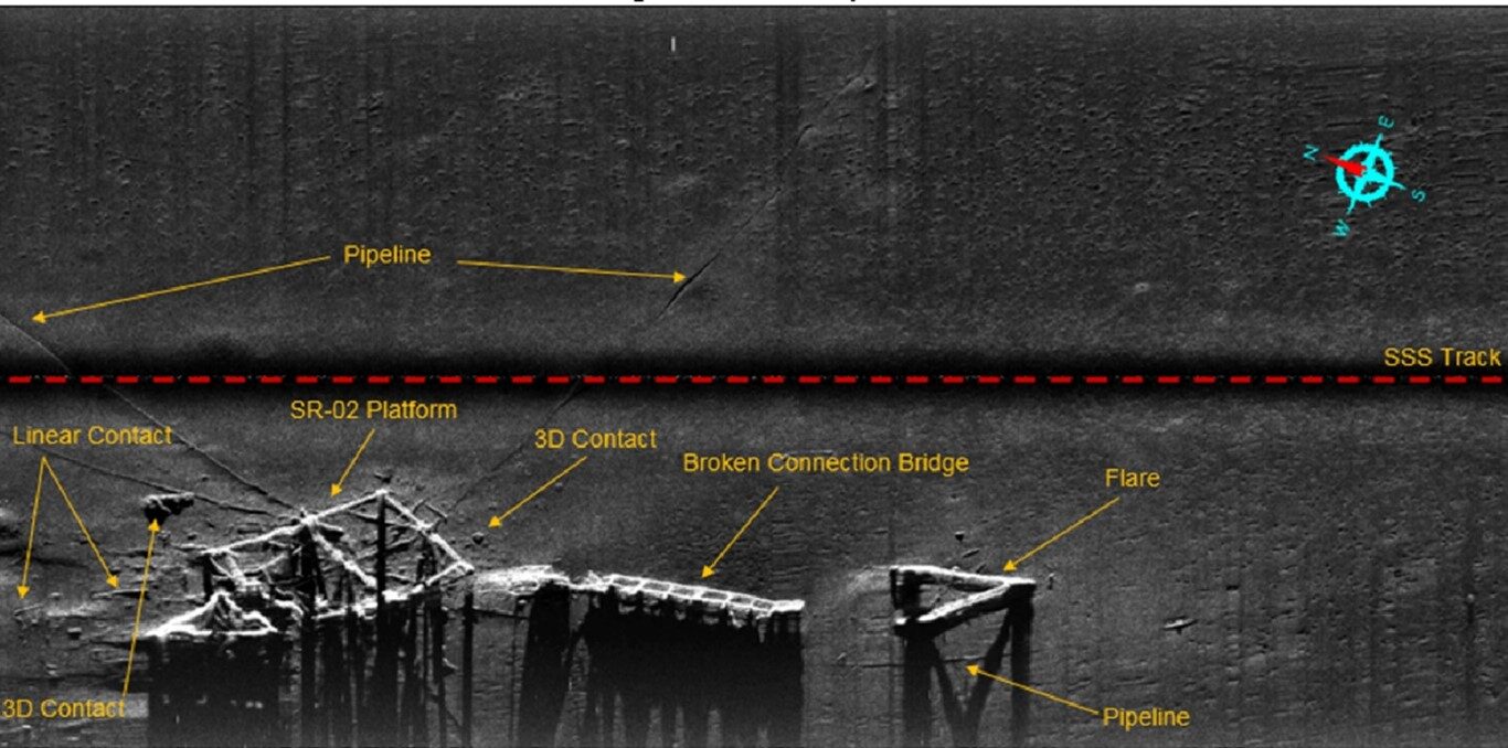
- Seabed features and obstructions
Traditionally by side scan sonar, modern mosaicking systems will provide an acoustic “photograph” of the seabed in which prominent features and morphology can be more easily understood and interpreted.
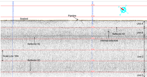
The Sub-Bottom Profiler will be deployed to identify strata below the seabed more over shallow gas can be extract from SBP Data.
For this type of survey operation, SUNRISE MARINE GEOSIENCES LTD uses the most recent technologies, equipment and methods to provide our customers with high quality data acquisitions and interpretations.
All result for pre-engineering survey is presented in the following reports:
- Final text report “Pre-Engineering Survey Final Report”
- Alignment sheets.
Pre-Engineering Survey
Because designing of subsea construction normally takes a long time after finishing the pre-engineering survey, it is necessary to perform another survey which is called pre-installation survey.
Due to time consuming designing procedure of any subsea construction, some changes can occur on the seabed such as removal/installation of pipelines, platforms, cables or sunken objects. Therefore, this survey is a mandatory for all offshore construction/installation companies.
All Results for pre-installation survey are presented in the following reports:
- Final text report “Pre-installation survey final report”
- Alignment sheets
Post-lay Survey
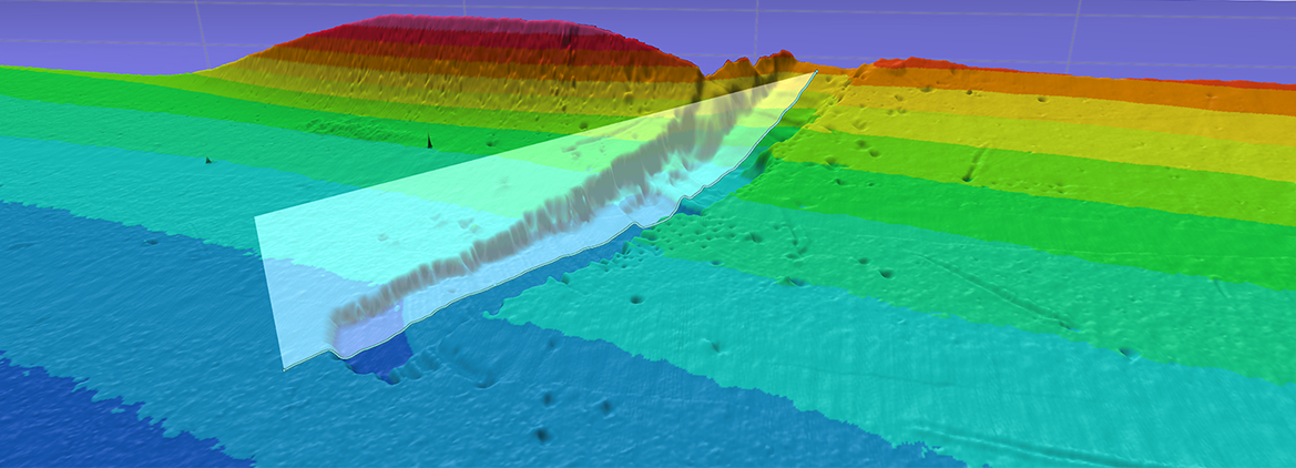
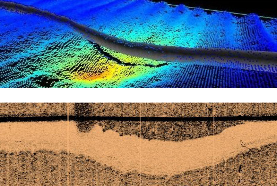
After the pipe-laying operation the most important accomplishment for pipe-line inspection is to determine the free span locations. The below figure demonstrates the free span detection by side scan sonar in conjunction with multi beam echo sounder deployment:
The SUNRISE MARINE GEOSIENCES LTD Geophysics Unit boasts a successful track record in the world, having completed over 245 projects encompassing more than twenty thousand kilometers of data collection.